British Virgin Islands
British Virgin Islands, Caribbean Sailing Made Natural
Seen from the water, the British Virgin Islands feel purpose-built for sailing. Islands sit close together, anchorages are well distributed, and steady trade winds support consistent daily movement. Unlike destinations defined by long open-sea legs, the BVI operates as a compact sailing system where each stop is visible from the last.
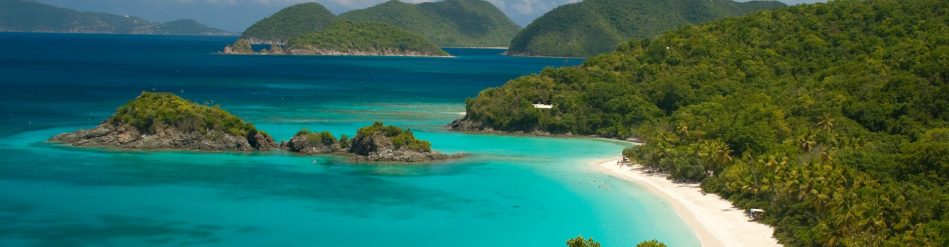
Located in the northeastern Caribbean, the archipelago includes Tortola, Virgin Gorda, Jost Van Dyke, Anegada, and numerous smaller cays. The geography creates protected channels between islands, reducing swell while maintaining open horizons. Water color shifts between deep blue and bright turquoise over sandy bottoms.
The BVI is structured for navigation. Distances are short, landmarks are clear, and anchorages are frequent. From the sea, the islands feel connected rather than isolated.
Why choose the British Virgin Islands for sailing?
Because they combine accessibility and variety. Within a limited radius, sailors experience beaches, rocky formations, reefs, and lively waterfront stops without extended passages.


Sailing the BVI, Island Hopping with Predictable Rhythm
Sailing in the BVI follows a logical island-hopping pattern. Short daily legs, often under 15 nautical miles, connect sheltered anchorages across the Sir Francis Drake Channel.
Tortola serves as the main base, with marinas and provisioning hubs. From there, routes naturally extend toward Virgin Gorda, known for The Baths, where granite boulders form sheltered pools along the shore. Westward, Jost Van Dyke offers relaxed anchorages and protected bays such as White Bay.
Further south, Norman Island provides clear-water snorkeling stops, while Anegada introduces a contrasting low coral atoll landscape, accessible via slightly longer but manageable passages.
Trade winds from the east remain relatively stable throughout the main season, creating reliable sailing angles between islands. The protection offered by surrounding land reduces open-ocean swell in most channels.
Is the BVI suitable for beginners?
Yes. The combination of short distances, line-of-sight navigation, and predictable winds makes the region one of the most accessible in the Caribbean. At the same time, experienced sailors can extend routes or explore less frequented anchorages. Catamarans are particularly popular due to shallow draft and comfort at anchor. IntersailClub typically structures BVI itineraries to maximize daily movement while maintaining flexible shelter options.
Here, sailing is continuous and intuitive.


Caribbean Heritage and Maritime Culture
The British Virgin Islands reflect layered Caribbean history. Indigenous communities, European colonial powers, and maritime trade routes shaped settlement patterns and coastal development. Small harbors evolved as natural trade points and remain central to island life.
Fishing and boating culture remain active, though tourism plays a major economic role. Waterfront communities integrate marinas, beach bars, and working docks within compact coastal settlements.
What defines the BVI’s identity today?
Maritime accessibility. The islands function as a network built around movement by boat. Even social life often revolves around anchorages and waterfront gatherings rather than inland centers.
Sailing reinforces this structure. Approaches are direct, anchorages visible, and navigation remains visually oriented rather than chart-dependent.
The BVI are not dramatic in scale. They are precise in design.
Climate and Sailing Conditions in the BVI
June is the hottest month in Havana with an average temperature of 27°C (81°F) and the coldest is January at 21°C (70°F) with the most daily sunshine hours at 11 in July. The wettest month is June with an average of 80mm of rain. The best month to swim in the sea is in August when the average sea temperature is 30°C (86°F).
Check all Statistics in Accuweather


