Panama
Panama, Where Two Oceans Shape One Country
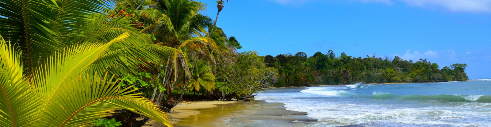
Seen from the sea, Panama feels like a narrow ribbon of land stitched between two vast horizons. To the north, the Caribbean stretches warm and turquoise, dotted with low coral islands and palm-fringed shallows. To the south, the Pacific opens wider and wilder, with volcanic silhouettes, stronger tides, and long, undeveloped coastlines. Few countries offer such a clear sense of contrast within such a compact geography.
Panama sits at the natural bridge between North and South America, but its identity is shaped just as much by water as by land. The country’s coastline runs for more than 2,400 km, wrapping around mangroves, reef systems, river deltas, and remote island groups. Inland, dense rainforest rises quickly from the shore, especially along the Caribbean side, where jungle-covered hills often meet the sea without transition. This closeness between land and water gives many coastal areas a feeling of isolation that has changed little over time.
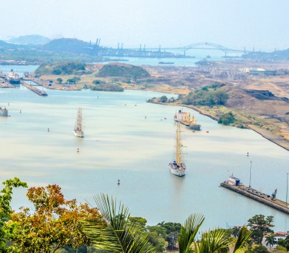
Travelers often associate Panama with the Panama Canal, and rightly so. The canal is not only an engineering landmark, but a cultural axis around which modern Panama developed. Yet beyond this transit corridor lies a quieter, more fragmented world. Archipelagos like the San Blas Islands or Bocas del Toro feel geographically and culturally distant from Panama City, shaped by Indigenous communities, Afro-Caribbean heritage, and a slower rhythm of life tied to tides and seasons rather than schedules.
On the Pacific side, the landscape shifts. Islands are fewer but larger, distances between anchorages increase, and the coastline alternates between fishing villages, protected bays, and long stretches of untouched nature. Marine life is abundant on both coasts, but the ecosystems differ: coral reefs and shallow lagoons in the Caribbean, deeper waters and seasonal whale migrations in the Pacific.
Why visit Panama instead of another Central American destination?
Because it offers diversity without long internal travel. In a single journey, it is possible to experience two seas, multiple cultures, and radically different coastal environments, all within a country small enough to feel coherent yet complex. Panama is not defined by one iconic beach or resort area, but by its transitions: between oceans, between cultures, and between the known and the still undiscovered.


Sailing Panama’s Two Coasts, From Coral Archipelagos to Open Pacific Horizons
Sailing in Panama is less about ticking off ports and more about moving through contrasting maritime worlds. The country’s narrow shape creates two very different sailing environments, each defined by its own geography, weather patterns, and rhythm of life. Understanding this duality is key to appreciating why Panama stands apart from most Caribbean or Central American sailing destinations.
On the Caribbean side, routes usually unfold among island groups rather than along a linear coastline. The most emblematic area is the San Blas Islands, an archipelago of more than 300 low-lying islands scattered across shallow, reef-protected waters. Navigation here is short-range and visual, with daily passages often lasting just a few hours. Anchorages are typically set over sand, close to palm-lined beaches and Kuna Yala communities, where life follows traditional patterns tied to fishing and small-scale trade. The sailing itself is generally relaxed, with steady trade winds and limited swell, making the area well suited to catamarans and skippered cruises. Snorkeling over coral gardens and anchoring near uninhabited islets are part of the daily routine.
Further west, Bocas del Toro offers a different Caribbean experience. Here, larger islands create sheltered channels, mangrove-lined bays, and short coastal hops. The distances remain manageable, but the atmosphere shifts toward a mix of local villages, Afro-Caribbean culture, and small-scale tourism. Sailing days often combine protected navigation with occasional open-water crossings, adding variety without demanding long passages.
The Pacific side of Panama tells a more expansive story. Routes typically involve fewer stops and longer legs, shaped by stronger tides and more pronounced currents. The Pearl Islands, located south of Panama City, form the core of most Pacific itineraries. These volcanic islands rise sharply from deeper water, with wide bays and anchorages exposed to open-ocean conditions. Navigation here feels more oceanic, with greater attention to timing, wind, and tidal flow. Wildlife encounters are a defining feature, especially during migration seasons when whales are commonly sighted along the routes.
Is Panama good for sailing?
Yes, but in a specific way. It rewards sailors who value variety over uniformity. Rather than offering one “perfect” coast, Panama provides a choice between intimate island-hopping in the Caribbean and more adventurous, open-water exploration in the Pacific. Platforms like IntersailClub typically approach Panama by matching travelers to the coast that best fits their experience level and expectations, recognizing that the two sides of the country deliver fundamentally different journeys.
In Panama, sailing is not just a way to move between places. It is the only perspective that reveals how sharply two oceans can shape a single destination.


Layers of History and Living Cultures Along Panama’s Shores
Panama’s coastal culture is inseparable from the sea. Long before the country became a global crossroads, its shores were shaped by Indigenous navigation, fishing routes, and trade networks that followed the rhythm of tides and seasons. This maritime foundation still defines daily life in many coastal regions, where history is not confined to museums but embedded in language, food, and customs.
On the Caribbean side, the identity of the Guna Yala region is central to understanding Panama’s cultural depth. The Guna people have maintained political autonomy and a strong connection to the sea, relying on fishing, coconut trade, and inter-island travel for generations. Their brightly patterned molas, hand-stitched textiles worn and sold by Guna women, are not souvenirs created for visitors but living symbols of identity, often depicting marine life, sails, and island landscapes. Sailing through this area means entering a cultural space where traditions remain active and visible, not staged.
Further west, around Bocas del Toro, Afro-Caribbean influences become more pronounced. Music, language, and cuisine reflect historical ties to Jamaica and other Caribbean islands, dating back to the banana trade and canal construction era. Dishes such as coconut rice with seafood or fried plantains are common along the coast, while local celebrations often blend Caribbean rhythms with Panamanian customs. The sea here is both a workplace and gathering place, shaping social life as much as geography.
The Pacific coast tells a different story, marked by Spanish colonization and global trade. Historic ports like Portobelo and Colón once handled vast quantities of silver and goods moving between continents. These routes laid the groundwork for Panama’s later transformation with the opening of the Panama Canal, an engineering feat that reshaped not only global shipping but also national identity. Coastal towns near the canal reflect this layered past, where maritime labor, migration, and international exchange intersect.
What cultural influences shape Panama’s identity today?
The answer lies in coexistence rather than fusion. Indigenous autonomy, Afro-Caribbean heritage, and Hispanic colonial roots exist side by side, each more visible along the coast than inland. Sailing makes these contrasts tangible. Moving by sea, it becomes clear how Panama’s culture is not uniform but segmented, shaped by currents, distances, and access to the water.
In Panama, coastal life is not a backdrop to travel. It is the thread that connects history, community, and landscape into a living maritime culture.
Climate, Winds, and Seasons, Planning When to Sail in Panama
June is the hottest month in Havana with an average temperature of 27°C (81°F) and the coldest is January at 21°C (70°F) with the most daily sunshine hours at 11 in July. The wettest month is June with an average of 80mm of rain. The best month to swim in the sea is in August when the average sea temperature is 30°C (86°F).
Check all Statistics in Accuweather


