Pontine Islands
Pontine Islands, Volcanic Outposts in the Central Tyrrhenian Sea
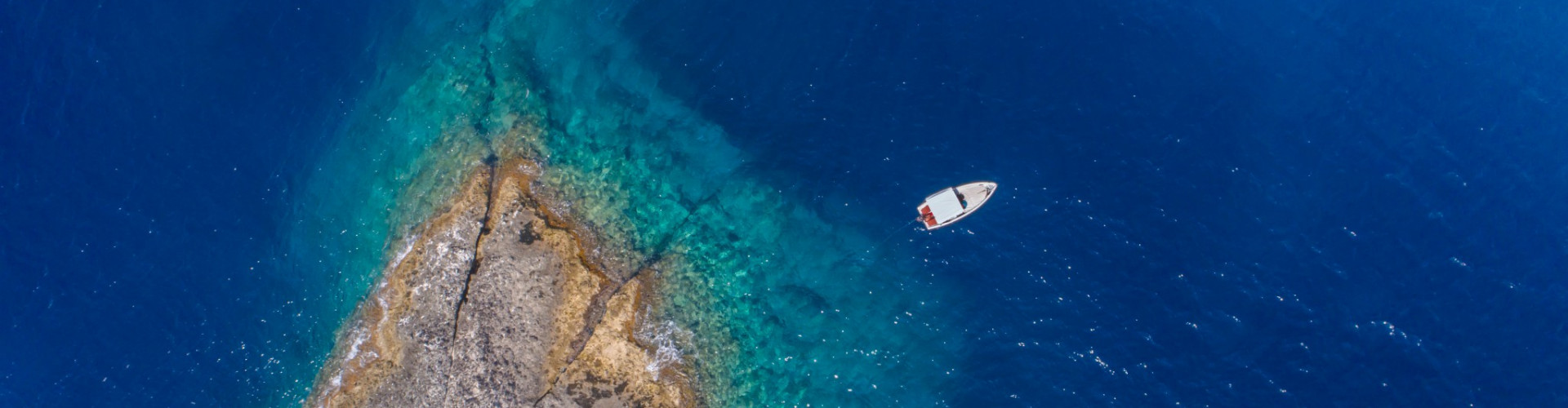
Seen from the water, the Pontine Islands appear fragmented and irregular, a chain of volcanic remnants scattered between Rome and Naples. Pale tuff cliffs, dark basalt layers, and sudden sea caves break the coastline into sharp contrasts. This is not a continuous shoreline but a sequence of interruptions, where land rises abruptly from deep water and then disappears again.
The archipelago lies off the southern coast of Lazio, isolated enough to feel detached from the mainland despite relatively short distances. Ponza is the largest and most populated island, followed by Ventotene. Palmarola and Zannone remain largely undeveloped, shaped more by wind and sea than by human presence.
From offshore, the volcanic origin of the islands becomes immediately clear. Rock layers reveal eruptions, collapses, and erosion over time, creating a coastline rich in texture and depth. On land, space is limited and steep, with few natural harbors and a constant sense of separation from the continent.
Why visit the Pontine Islands instead of other Italian destinations?
Because they offer reduction rather than abundance. There are no long sandy beaches, no large towns, and little visual comfort. The experience is built around short stops, quiet nights at anchor, and a dominant sea presence. The Pontine Islands are not expansive. They are precise.


Sailing the Pontine Islands, Compact Routes and Selective Anchorages
Sailing among the Pontine Islands is concentrated and demanding in the best sense. Distances are short, yet conditions can shift quickly depending on exposure and wind. This makes the archipelago well suited to exploratory itineraries, where planning is based on daily conditions rather than fixed routes.
Ponza usually serves as the natural starting point. Its coastline offers a variety of coves and caves, including Chiaia di Luna and Cala Feola, where anchoring is often possible on sandy patches close to steep rock walls. The island’s irregular shape provides multiple exposures, allowing skippers to adjust plans according to weather and swell.
A few miles offshore, Palmarola changes the scale entirely. With no real port, only natural inlets and vertical cliffs, it represents the most uninhabited face of the archipelago. Anchorage options are limited and require care, but the isolation and water clarity make Palmarola one of the most striking stops in the Tyrrhenian Sea.
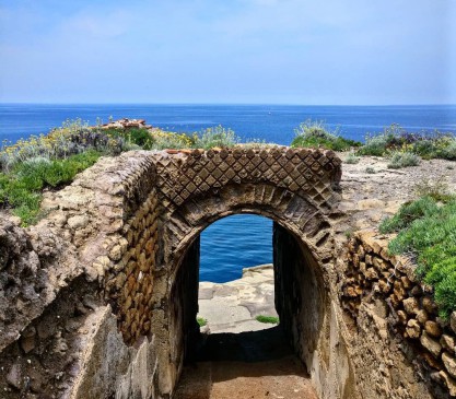
Ventotene offers a different atmosphere. Its Roman-era harbor, carved directly into volcanic rock, remains one of the oldest functioning ports in the Mediterranean. The island’s flatter profile and organized layout contrast sharply with the raw relief of Ponza and Palmarola.
Zannone, part of a protected natural area, is rarely accessible and largely observed from the sea. Its presence adds an environmental dimension to the route, reinforcing the sense of reserve and limitation that defines the Pontine Islands.
Are the Pontine Islands good for sailing?
Yes, for sailors who value variety within a small radius. Catamarans and mid-sized sailing yachts are common, often with a skipper to manage anchoring constraints and local regulations. IntersailClub typically approaches the Pontine Islands as a destination where knowledge of exposure and weather windows matters more than distance covered.
Here, sailing is not simply transport. It is the only practical way to experience the islands.


Isolation, Exile, and a Culture Shaped by the Sea
The history of the Pontine Islands is marked by separation. In Roman times, Ventotene was used as a place of exile for political figures, its remoteness serving as a tool of control. Remains of villas and maritime infrastructure point to an organized presence, but never to large-scale settlement.
For centuries, the islands remained marginal, exposed to piracy and difficult to sustain. Only in the Bourbon period did more stable communities form, particularly on Ponza, with populations relying on fishing, navigation, and subsistence agriculture. This relatively recent settlement explains the absence of monumental heritage and the presence instead of a practical, adaptive culture.
What defines the Pontine identity today?
Simplicity and seasonality. Cuisine centers on local catch, daily rhythms follow weather patterns, and community life contracts sharply outside the summer months. In high season the islands feel animated, but outside it they return to a suspended, almost austere state.
Sailing along the coast makes this history legible. Harbors, anchorages, and settlements are positioned according to protection and access, not visual appeal. The sea dictated where life could exist, and where it could not.
The Pontine Islands do not tell a story of power or wealth. They tell a story of endurance at the edge.
Climate and Sailing Conditions in the Pontine Islands
June is the hottest month in Havana with an average temperature of 27°C (81°F) and the coldest is January at 21°C (70°F) with the most daily sunshine hours at 11 in July. The wettest month is June with an average of 80mm of rain. The best month to swim in the sea is in August when the average sea temperature is 30°C (86°F).
Check all Statistics in AccuweatherAll destinations in Mediterranean Sea
-

-
-
-
-
-
-
-
-
-
-
-
-
-
-
-
-
-
-
-
-
-
-
-
-
-
-
-
-
-
-


