Aeolian Islands
Aeolian Islands, Volcanic Sailing in the Tyrrhenian Sea
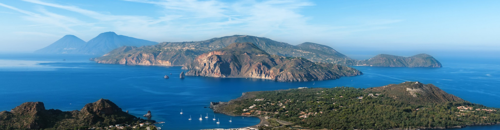
Approaching by sea, the Aeolian Islands feel elemental. Rising sharply from deep blue water north of Sicily, the archipelago is defined by volcanic structure rather than gentle coastline. Cones, cliffs, black sand beaches, and fumaroles shape a landscape that feels in motion, even when the sea is calm.
The Aeolian group consists of seven main islands, each distinct in form and character. Lipari is the largest and most developed, Salina greener and more agricultural, Vulcano marked by sulfuric fumaroles, and Stromboli home to one of Europe’s most active volcanoes. Smaller islands such as Panarea, Filicudi, and Alicudi add further variation, from refined harbors to near isolation.
Unlike sheltered archipelagos, the Aeolian Islands sit fully exposed in the Tyrrhenian Sea. Distances between islands are short in nautical terms, but open-sea conditions are part of the experience. Sailing here is not enclosed. It is panoramic.
Why choose the Aeolian Islands for sailing?
Because they offer drama without artificiality. The landscape is geological, not decorative. Every approach feels defined by scale and contrast.


Sailing the Aeolian Islands, Open Crossings and Defined Anchorages
Sailing in the Aeolian Islands combines short inter-island legs with exposure to open water. The islands are close enough to structure flexible itineraries, yet far enough apart to require deliberate planning and weather awareness.
Lipari often serves as a logistical base, offering the most extensive harbor and services. From here, routes expand naturally. A short sail leads to Vulcano, where anchorages sit beneath smoking craters. Crossing north toward Salina introduces greener slopes and sheltered bays. Continuing east, Stromboli rises abruptly from the sea, its nighttime eruptions visible directly from anchored boats.
Anchorages are generally limited to specific coves with suitable holding, and protection depends strongly on wind direction. Unlike flat island chains, volcanic slopes drop quickly into deep water, restricting where boats can safely remain overnight.
Is the Aeolian archipelago suitable for beginners?
It can be, but with preparation. Distances are manageable, yet exposure to prevailing winds such as mistral can create more challenging sea states. Catamarans and monohulls are both common, and many itineraries are skippered to align route decisions with forecasts. IntersailClub typically treats the Aeolian Islands as a dynamic sailing ground, where route flexibility is essential.
Here, sailing is not confined to calm corridors. It unfolds across visible open water.


Echoes from the Sea: Tracing the Cultural Soul of the Aeolian Islands
The Aeolian Islands derive their name from Aeolus, god of the winds, a reflection of their long association with navigation. Since antiquity, the islands have been used as stopping points for Mediterranean trade routes, offering shelter, resources, and strategic observation.
Volcanic activity shaped not only the landscape but also settlement patterns. Villages developed around natural harbors, with whitewashed houses contrasting against dark rock. Fishing remains part of daily life, though tourism has become central during summer months.
What defines Aeolian identity today?
Coexistence between activity and stillness. Stromboli continues to erupt, Vulcano releases sulfuric steam, and daily life continues around these phenomena. Unlike dormant landscapes, the Aeolian Islands retain visible geological presence.
Sailing reinforces this sense of continuity. Anchorages lie beneath active craters, and night passages reveal glowing volcanic slopes. The sea remains the primary connector between islands, just as it has been for centuries.
The Aeolian Islands are not shaped by human design. They are shaped by geological time.
Climate and Sailing Conditions in the Aeolian Islands
June is the hottest month in Havana with an average temperature of 27°C (81°F) and the coldest is January at 21°C (70°F) with the most daily sunshine hours at 11 in July. The wettest month is June with an average of 80mm of rain. The best month to swim in the sea is in August when the average sea temperature is 30°C (86°F).
Check all Statistics in AccuweatherAll destinations in Mediterranean Sea
-

-
-
-
-
-
-
-
-
-
-
-
-
-
-
-
-
-
-
-
-
-
-
-
-
-
-
-
-
-
-


